On This Page
Define the record before collecting data
Agree on the intended use first: documenting visible condition, comparing repeat
visits, measuring a surface, or creating an asset register. Then ask the person
who will use the result which files and contextual information they need. A
maintenance team looking for photographs by asset ID has a different handoff
from a geospatial analyst importing a surface model.
Metadata are the descriptions that make data understandable and reusable.
USGS metadata guidance
ties that description to who collected the data, what it represents, where and
when it was acquired, and how it was created. For a commercial job, use those
questions to write a short project README and a file index before the first
collection.
Record the project and asset identifiers, collection date and time basis,
responsible team, sensor, intended coverage, and delivery contact. Identify the
meaning and units of fields in any exported table. Keep acquisition time
separate from upload and processing time. If a time is local, retain its UTC
offset; an unexplained timestamp is a poor way to match records from different
systems.
For mapping, identify the coordinate reference system, horizontal and vertical
reference, units, and any local site transformation. Do not leave the recipient
to infer these from a filename. The
USGS UAS data dictionary
illustrates how project, mission, sensor, original filename, datum, projection,
and data type can be recorded separately. Its catalog conventions are a useful
reference, not a mandatory commercial naming scheme.
Define responsibilities at the same time. Name who checks field completeness,
who releases the processed result, who receives it, and who remains responsible
for the retained record. Make delivery format and retention an explicit part of
the scope rather than an assumption discovered at invoicing.
Move files off the card without losing their identity
Use a repeatable ingest procedure: identify the card and collection, copy the
original files with their associated sidecars and logs, and verify the transfer
before releasing the card for reuse. Preserve original names inside distinct
collection folders so repeated camera filenames cannot silently overwrite one
another.
A cryptographic hash is a fingerprint calculated from a file's bytes. Comparing
a newly calculated hash with a protected earlier value helps detect changes.
NIST IR 8387
recommends recording file origins and protecting stored hashes separately from
the files. Its focus is digital evidence handling; the integrity principle is
useful here without making this workflow a forensic certification.
Create a manifest listing relative path, byte size, hash algorithm, and hash
value. Keep a protected baseline and compare the destination files against it.
If a comparison fails, retain the mismatch record, investigate the affected
transfer, and recopy from a verified source. Do not replace the baseline merely
to make the comparison pass.
Keep these locations distinct:
- Original capture: preserved source files, with restricted write access.
- Working data: copies used for processing and analysis.
- Released delivery: the exact files sent to the client, identified by
version.
The card-reuse decision should include a verified recovery copy.
USGS backup guidance
recommends backing up metadata with data, separating backup locations, and
checking that copied files open correctly and match their originals. Two folders
on the same device do not provide that separation.
Keep each processing run traceable
Processing can generate a new result without changing the source photographs.
Preserve a run record connecting the exact input set to software and version,
settings, calibration inputs, coordinate transformations, exclusions, and output
filenames.
USGS processing guidance
explains why documenting alterations and retaining inputs matters for
reproducibility.
Use a new run identifier when changing inputs or methods. For example, if an
analyst removes blurred photographs and reruns a reconstruction, retain the
exclusion list and its reason. Keep the original photographs in the capture set.
A later reviewer should be able to distinguish an intentional exclusion from a
missing file.
For a result derived from several inputs, record those relationships explicitly.
A surface may depend on many images and control measurements; it is rarely
enough to attach one representative photograph. Save native project files where
they are needed to inspect the work, plus agreed exchange formats that the
recipient can use.
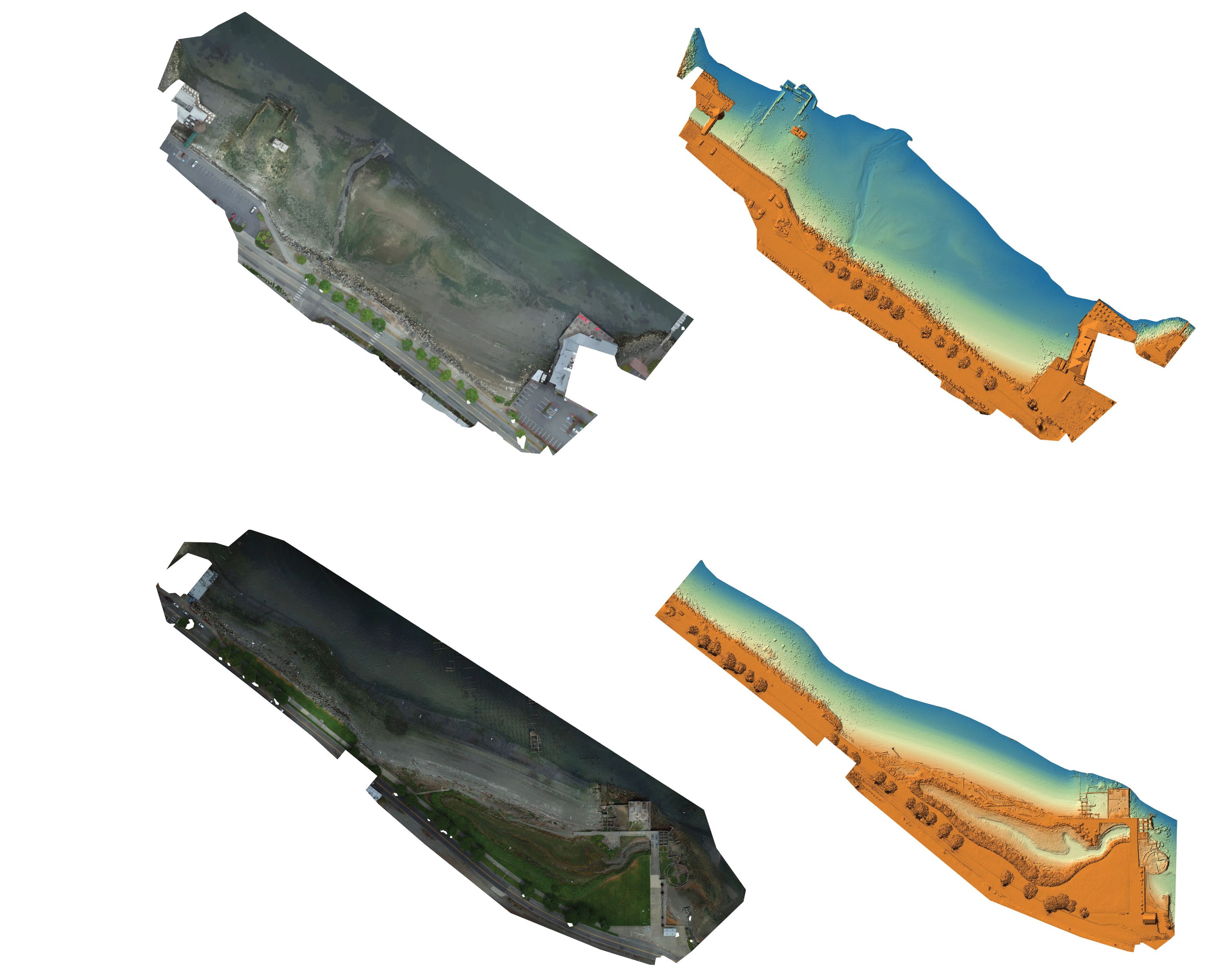
An example of distinct products from one acquisition appears in the featured
USGS image: the
Puget Creek and Dickman Mill Park survey
produced orthomosaic imagery, a digital surface model, and point-cloud data from
a June 2019 UAS collection. A delivery should identify which product each file
contains and the processing run that produced it.
Annotation changes also need a history. If a finding is reclassified, retain its
stable ID, prior interpretation, replacement interpretation, author, and reason.
Updating a report should produce a new delivery version rather than silently
replacing the file the client previously accepted.
Separate intact files from reliable measurements
A matching hash supports byte integrity relative to the baseline. It does not
establish whether a camera clock was correct, whether the intended asset was
photographed, or whether a measurement is accurate. Those questions need
collection context and quality checks of their own.
For photogrammetry, separate points used to position a model from points used to
assess it.
Pix4D's tie-point documentation
distinguishes ground control from checkpoints and describes comparing known
checkpoint positions with reconstructed positions. Record the method, reference
measurements, distribution of checks, and reported errors. A small error near a
checked location does not demonstrate identical performance across untested
areas.
Similarly, specify image coverage independently of file completeness. A
successful transfer can preserve every photograph while the collection itself
still misses a required face of an asset. Keep an exceptions list that
identifies the affected area, the missing observation, and the consequence for
the requested deliverable.
For inspection work, connect each finding to its supporting image or other
record and state what still needs confirmation. The distinction between
observation, measurement, and diagnosis is explored in
what drone-inspection evidence can prove.
Specify a handoff the client can check
The following is a proposed commercial handoff specification, synthesized from
the preservation, metadata, processing, and quality guidance above. The checks
are commissioning recommendations, not reported test results or universal
accuracy requirements.
Scroll horizontally to compare all columns.
Set numerical criteria before capture where the use requires them. Agree on the
measurement method, units, acceptable error, and coverage requirement together.
A number without its checking method invites disagreement at handoff.
For example, consider a hypothetical job requiring photographs of 40 identified
assets. If 38 have usable records and two are inaccessible, the reported asset
coverage is 38 ÷ 40 × 100 = 95%. That is an illustrative completeness
calculation, not a measured project outcome or a claim about defect detection.
The two exceptions remain part of the delivery even if every transferred file
passes its integrity check.
Require a sample import before accepting a recurring service. Have the intended
recipient open a representative deliverable, find a specified asset, inspect its
supporting capture, and identify the corresponding processing run. Record the
actual result. This exercise gives a buyer a concrete basis for assessing the
handoff.
Choose storage and software around retrieval
Start with the record you need to retrieve, then choose the platform. A small
team may be able to manage a modest collection through controlled folders, a
manifest, and a documented backup procedure. A larger operation should assess
whether its software can preserve the same relationships across users and
repeated visits.
Ask prospective providers to demonstrate:
- Export of originals, metadata, annotations, and processing history, with the
actual file formats identified.
- Separation of permissions for capture upload, editing, release, and deletion.
- Identification of the exact version a client received.
- Recovery of an earlier delivery after a mistaken change or deletion.
- Retrieval after a subscription ends, including who performs the export and
what remains readable.
Treat these as purchase questions, not presumed capabilities. Request contract
terms for storage location, retention, deletion, and export charges rather than
inferring them from a sharing screen. Include an archive owner and a review date
in the project record.
Choose backup frequency from the amount of work the business can afford to lose,
and recovery arrangements from how soon it must resume work. In a recovery
exercise, record elapsed retrieval time, missing files, integrity mismatches,
and whether the receiving application opens the restored outputs. Compare those
observations with the project's agreed recovery needs. An archive is only useful
if the next person can locate a released package and understand it.
Before closing the next job, ask someone outside the processing team to retrieve
one finding and follow it back to its source. If they can identify the
collection, explain the processing, see the limitations, and open the delivered
version, the record is ready for a meaningful client review.
Source notes
- USGS: Metadata Creation.
Institutional guidance on documenting context so data can be understood and
reused.
- USGS: UAS Data Dictionary.
Government catalog definitions for acquisition, sensor, spatial, and file
information.
- NIST IR 8387: Digital Evidence Preservation.
September 2022 technical report on origins, integrity checks, and
preservation; not a drone-specific certification.
- USGS: Backup & Secure.
Institutional guidance on separated backups, metadata preservation, and copy
verification.
- USGS: Process. Guidance on
preserving inputs and documenting changes and methods.
- USGS: Tacoma orthomosaic and surface-model examples.
Government image record describing products from the June 3, 2019 UAS survey;
also establishes the featured image's origin and public-domain status.
- Pix4D: Tie points in a photogrammetry project.
Provider technical documentation distinguishing ground control, checkpoints,
and other tie points.
Last checked: September 8, 2026.