On This Page
What each method actually measures
Photogrammetry finds corresponding features in photographs taken from different
positions and uses their geometry to reconstruct a scene. The capture plan
therefore needs overlapping views, sharp images, and enough stable detail to
match. Its outputs can include a three-dimensional point cloud and an
orthomosaic, a geometrically corrected mosaic of photographs. PIX4D's
image-acquisition guidance
explains the dependencies on image geometry, exposure, overlap, and surface
characteristics.
Airborne LiDAR combines measured ranges with satellite positioning, an inertial
measurement unit that tracks motion and orientation, scan angles, and
calibration information.
NOAA's explanation of LiDAR
describes how these inputs locate individual reflections in three dimensions.
Accurate ranging is only one part of that chain: the system also has to know
where the laser was and where it pointed.
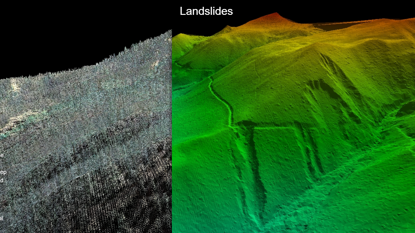
Some laser energy can reach the ground through openings in vegetation. Multiple
returns can describe different surfaces encountered along a pulse's path. This
does not mean the laser sees through solid leaves, or that every last return is
ground. Classification identifies likely ground points; a terrain model is then
built from the retained observations. The
USGS point-cloud and bare-earth example
shows why this processing matters: removing vegetation from the representation
exposes terrain features masked by the canopy.
A digital surface model includes the visible upper surfaces of vegetation and
structures. A bare-earth terrain model aims to represent the ground. Filtering a
photogrammetric cloud cannot recover ground that the photographs never observed.
Similarly, a continuous LiDAR terrain model can contain interpolated areas where
ground returns were sparse. Ask where the surface is measured and where it is
estimated.
Match the method to the commercial mission
Use the table to shortlist a capture method, then test the proposed approach
against the difficult parts of the actual site. These are editorial selection
recommendations based on the measurement mechanisms and limitations in NOAA,
PIX4D, and USGS guidance, rather than measured rankings of particular systems.
Scroll horizontally to compare all columns.
For stockpiles, neither an overhead camera nor an overhead laser measures the
buried base through the material. Agree how the base surface is established
before using either method to calculate volume.
Vegetation is a strong reason to consider LiDAR, but also a reason to scrutinize
the collection plan. The
USGS collection requirements
prefer leaf-off conditions and require adequate ground penetration for a
reliable bare-earth surface. They also recognize gaps caused by water, low
near-infrared reflectivity, and shadowing by structures. These are 3D Elevation
Program requirements, not automatic rules for every commercial drone job, but
they identify useful questions for a supplier.
Water needs separate treatment. PIX4D describes open water as particularly
difficult to reconstruct because it moves, reflects, and lacks stable visual
features. Conventional topographic LiDAR should not be assumed to measure the
bottom either: NOAA distinguishes its typically near-infrared laser from the
green light used by bathymetric systems. If submerged ground matters, specify a
suitable bathymetric method separately.
Compare accuracy on the same basis
There is no defensible single answer such as “LiDAR is accurate to X
centimeters; photogrammetry to Y.” The result depends on equipment, collection
geometry, positioning, calibration, land cover, processing, and the final
product being assessed.
Resolution describes sampling. Image ground sampling distance describes the
ground spacing represented by adjacent pixels. LiDAR density describes how many
points or pulses occupy an area, depending on the stated definition. Neither
number proves that the coordinates are correct. The
USGS UAS calibration report
emphasizes that ground control and tie-point quality contribute to geometric
accuracy independently of image ground sample distance.
Internal consistency and absolute accuracy answer different questions. Two
overlapping flight strips can agree with each other while the whole dataset is
displaced relative to the project's reference system. A small camera-alignment
residual likewise does not demonstrate accuracy against independent ground
measurements. The distinction between images and supported measurements also
matters when deciding
what a drone inspection can actually prove.
Ask both bidders to report horizontal and vertical performance separately,
identify the statistic used, and show the tested surface and land-cover
conditions. Require the report to explain whether its number is a statistical
summary or a maximum permitted error. Do not compare a sensor's ranging
specification, a positioning estimate, and a finished terrain model's checkpoint
result as if they were the same measurement.
The
USGS processing requirements
distinguish internal precision from absolute accuracy and require checkpoints
independent of calibration control. For a commercial brief, agree the applicable
accuracy standard, edition, statistic, checkpoint survey quality, and
distribution before collection. Include the relevant vegetated areas when those
areas determine whether the deliverable is useful; a good result on an open
parking lot does not establish performance beneath trees.
Follow the work from collection to delivery
Both methods need a project boundary, a defined surface, a control and
checkpoint plan, and an agreed horizontal and vertical coordinate reference
system. If the mapping is joining an existing engineering project, resolve the
units and elevation reference before flying. A transformation discovered at
handover can affect the entire delivery.
For photogrammetry, the core production sequence is image collection, image
alignment and camera calibration, dense reconstruction, surface editing, and the
requested map or model exports. Review sharpness and coverage early. Missing
views, weak visual texture, moving vegetation, and severe reflections can leave
areas that need another capture or a different measurement method. USGS
calibration guidance treats flight configuration, control placement, camera
calibration, and quality verification as interdependent tasks.
For LiDAR, the sequence includes positioning and inertial trajectory
processing, calibration and alignment of the sensor system, point-cloud
generation, checking overlapping swaths, classification, and surface production.
Boresight calibration concerns alignment between the scanner and the
positioning-orientation system. An attractive cloud still needs review for strip
mismatch, noise, misclassified vegetation, and missing ground.
The
USGS deliverables requirements
provide a useful example of the supporting work: trajectory records, calibration
and swath-adjustment descriptions, classification methods, ground survey
reports, and accuracy evidence accompany the outputs. A commercial buyer can use
these categories to agree a proportionate handover without adopting the entire
national mapping specification.
If combining LiDAR and photography, make alignment and timing explicit. Include
the camera capture and image processing in the proposal; a laser-only delivery
does not supply an orthomosaic. Record the capture dates, coordinate references,
and checks used to reconcile the datasets. A colored point cloud is useful
context, but it should not be treated as proof that every image-derived feature
and laser point coincide correctly.
Compare the cost of an accepted deliverable
Ask for matched scopes before comparing headline prices. A quote for flight and
an unclassified point cloud covers different work from a quote for edited
terrain, contours, imagery, and an accuracy report. The following cost structure
is a budgeting recommendation, not a market-price estimate.
Total delivered cost = collection + ground survey + processing and editing +
quality checks + handover + additional work needed to close coverage gaps.
For each proposal, request the same breakdown:
- Collection: mobilization, aircraft and sensor provision, flight coverage,
and any separate photography.
- Ground survey: access, control establishment, independent checkpoints, and
any supplemental ground measurements.
- Processing: software, computing, operator time, classification, surface
editing, and feature extraction.
- Delivery: the agreed files, documentation, accuracy assessment, and import
support.
- Rework: which conditions trigger another flight or ground visit, who
decides it is necessary, and how it is priced.
Then identify which item could change the choice. On an open site that primarily
needs visual records, ask what additional deliverable would justify LiDAR. On a
wooded terrain project, ask whether a camera-only bid includes any credible way
to measure obscured ground. Its initial price is not a complete comparison if
that work remains outside the quote.
For an in-house capability, also compare acquisition or rental, training,
software access, maintenance, processing capacity, and expected utilization. Use
the
drone payload integration checklist
to assess the integration work behind that capability. Do not infer annual
savings from a sensor price alone. A service quote for the actual mission is a
useful alternative to ownership when recurring demand and staffing are still
uncertain.
Put the selection into the scope of work
Choose the method after agreeing the deliverable with the people who will use
it. Put six items in the request for quotation:
- The decision being supported, the project boundary, and the required capture
date or interval.
- The surfaces and features required, including obscured areas, stockpile
bases, and explicit exclusions.
- The accuracy requirement and how independent checks will assess the final
product.
- The image resolution or point-density definition, ground-coverage
expectations, and treatment of gaps.
- The coordinate reference system, units, file formats, classifications, and
receiving software requirements.
- The evidence and remedy required when a difficult area cannot be captured
adequately.
For a mixed site, request a representative sample that includes the hardest
vegetation or surface, not only a clean open patch. Have the intended recipient
inspect the proposed files and supporting quality report. This makes the choice
concrete before committing to full collection.
Specify photogrammetry when visible surfaces and useful photography fulfill the
job. Specify LiDAR when its ground-sampling capability resolves a material
visibility problem, and require evidence that it succeeds under the site's
conditions. Commission both when their distinct outputs are necessary. The
winning proposal is the one that covers the required surface, verifies the
result, and includes the work needed for delivery.
Source notes
- What is lidar? (NOAA): laser
measurement, positioning and orientation inputs, and topographic versus
bathymetric systems.
- Best practices for image acquisition and photogrammetry
(PIX4D): primary software guidance on capture geometry, imagery, and difficult
surfaces.
- Lidar point cloud vs. bare earth DEM
(USGS): terrain interpretation example and public-domain featured image.
- Lidar Base Specification: Collection Requirements
(USGS, 2025 rev. A): ground coverage, collection conditions, and data gaps.
- Guidelines for calibration of uncrewed aircraft systems imagery
(USGS, 2023): calibration, control, and geometric data quality.
- Lidar Base Specification: Data Processing and Handling Requirements
(USGS, 2025 rev. A): coordinate references, independent checkpoints, and
accuracy distinctions.
- Lidar Base Specification: Deliverables
(USGS, 2025 rev. A): trajectory, calibration, classification, and handover
records.
Last checked: September 7, 2026.